OsmAnd 4.5 (iOS)

Hello, everyone!
We are pleased to announce the release of a new version of OsmAnd for iOS.
What's new
- Free backup of favourites, settings and OSM edits to OsmAnd Cloud.
- Redesigned topography menus and added New Relief format.
- Contour lines plugin has been renamed to Topography.
- Added support for the new Terrain map format.
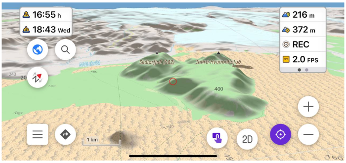
- Added 3D Relief.
- Added a separate button for switching 2D/3D Mode.
- The direction of the Tilt gesture has been changed.
- Redesigned Configure Screen.
- Completely redesigned widget experience:
- Added ability to change widget position.
- Added grouping by pages.
- Unified widget list for left and right panels.
- Added Average speed widget.
- Added True bearing widget.
- Difficulty classification - Configure Map
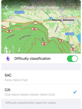
- Added CAI scale for Difficulty classification of the routes
- More updates in this release.
OsmAnd Start
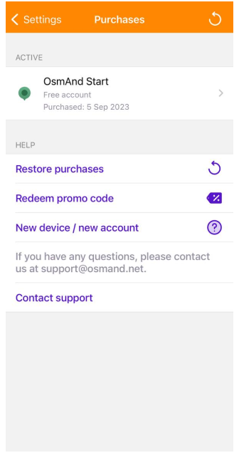
The OsmAnd Start plan has been added for OsmAnd 4.5. The user needs to register their email for OsmAnd Cloud first and then activate OsmAnd Start.
- Go to OsmAnd Menu → Settings → OsmAnd Cloud
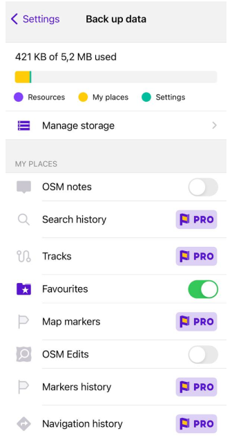
- After that, you can backup your Profiles, Favorites, OSM Edits and Notes, and OsmAnd settings for free.
- Size of OsmAnd Free Cloud - 5 MB
- Read more about OsmAnd Start in our OsmAnd Cloud article.
| Purchases menu | Back up data menu |
|---|---|
 |  |
Topography and 3D Relief
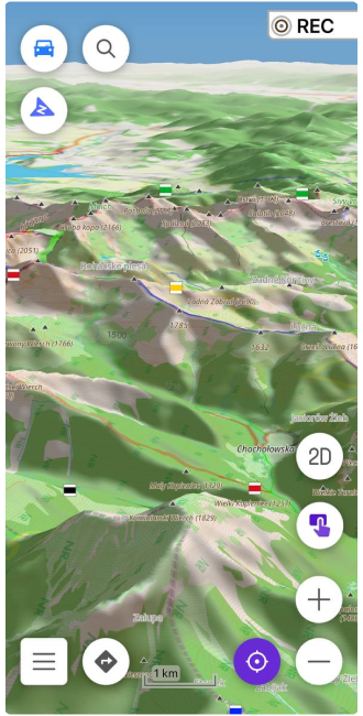
Terrain map for countries has been added to the Download maps menu. This data type can be used to generate Slopes, Hillshades (paid), and 3D maps (OsmAnd Pro).
Our updates:
-
The Contour Lines plugin has been renamed to the Topography plugin for a more visual and intuitive display of plugin functionality.
-
Added support for a new form of Terrain map (3D) (paid function). This map data is used for generated Slopes/Hillshades, 3D map view. Read more here.
-
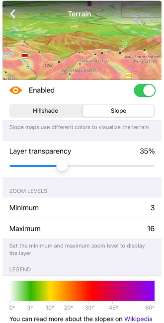
Slope and Hillshades are now generated from Terrain map (3D) data.
-
Added 3D Relief for the map (paid function). You can find it here: Menu → Configure map → Terrain → 3D Relief.
-
Redesigned Topography menu in Configure map menu. You can find it here: OsmAnd menu → Configure map → Topography: Contour lines, Terrain, Nautical depth.
-
Added a new 3D/2D Mode button for the map screen, and now map tilts can be done not just with a two-finger gesture. You can set parameters such as Hidden, Visible, Visible in 3D mode for the button. Available here: OsmAnd Menu → Configure Screen → Buttons → 3D Mode.
-
Changed direction of titlt gesture.
** map tilt angle by button is the last tilt angle by two-finger gestures.
Read more about Terrain maps in our Blog article.
| Slope | 3D relief |
|---|---|
 |  |
New Configure Screen
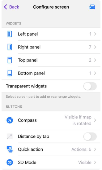
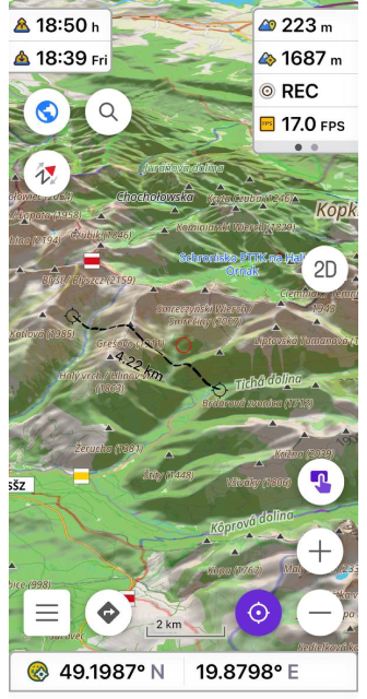
Configure Screen menu has been divided into two sections: Widgets and Buttons.
- In the Widgets section, you can add or remove widgets on the device screen, as well as switch Transparent function on/off for them. Read more about new widget updates in this article.
- In the Buttons section, you can add them to the device screen and set parameters for Compass, Quick Action, 3D mode buttons and switch on/off Distance by tap function.
| Configure screen menu | Widgets and buttons on a screen |
|---|---|
 |  |
Widget updates
We've done a lot of work on the widgets and interface of the Configure screen.
- The Configure screen has been redesigned, separating the widgets from buttons, and the different widget panels more clearly arranged.
- Added pages for widgets.
- Added an option to duplicate widgets.
- Combined the widgets from the left and right panels, and the top and bottom panels.
Pages and Duplicates for widgets
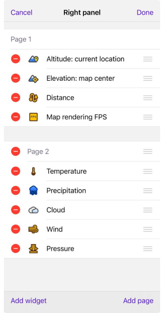
Widgets in the Left and Right panels can be grouped into Pages.
Duplicates can be shown simultaneously for the right and left panels, as well as for each widget page.
- Available here:
OsmAnd menu → Configure screen → Widgets (Left / Right panel) → Edit → Add widget/Add page - Additional settings menu for widget panels:
OsmAnd menu → Configure screen → Widgets (panels) → "..." button → Reset to default/Copy from another profile/Help
| Configure screen menu | Widgets and buttons on a screen |
|---|---|
 |  |
Average speed widget
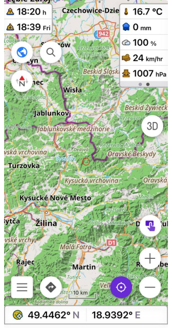
This widget shows your average speed for a selected time interval and does not require any other features such as track recording or navigation. You can easily use it to check if your average speed is in line with highway speed limits, or record your average speed for the last 5-15 minutes of cycling.
Available here: Menu → Configure screen → Widgets → Left / Right panel → Average speed
True bearing widget
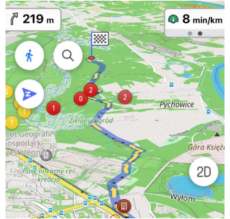
Added new widgets for Bearing. Bearing now has 3 separate widgets.
Menu → Configure screen → Widgets → Left / Right panel → Bearing
- Relative bearing is the angle between your forward movement direction and the target point.
- Magnetic bearing is the clockwise (horizontal) angle between the magnetic north and the target point observed from your location.
- True bearing is expressed as the horizontal angle between the geographic meridian and a line on Earth. Specifically, true point bearing is the angle measured in degrees clockwise from the True North line.
Update for Configure Map
Added CAI (Club Alpino Italiano) scale to classify the difficulty of routes.
OsmAnd Menu → Configure map → Routes → Difficulty classification
More
- Fixed an issue with exporting favorites that could cause data loss.
- Added Announce deviation from the route for Voice prompts.
- OSM authorization through OAuth. Read more about Login settings here.
We appreciate your interest in us and thank you for taking the time to read this article. Join us on social media to keep up to date with the latest news and share your experiences. Your opinion is important to us.
Follow OsmAnd on Facebook, TikTok, X (Twitter), Reddit, and Instagram!
Join us at our groups of Telegram (OsmAnd News channel), (EN), (IT), (FR), (DE), (UA), (ES), (BR-PT), (PL), (AR), (TR).
