OsmAnd 4.8 (Android)

Good news!
We are excited to announce the release of OsmAnd version 4.8 update for Android devices, which is already available for download on Google Play. This latest update introduces many new features and improvements to enhance your navigational experience.
To take advantage of these new features and improvements, visit Google Play or your preferred app store to download or update OsmAnd to version 4.8. We strive to make OsmAnd the best navigation tool for Android users, and we cannot wait for you to experience the latest advancements.
Thank you for your continued support of OsmAnd. Happy journey!
What's new
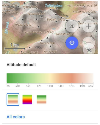
- Altitude terrain colorization option.
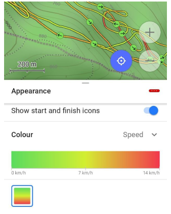
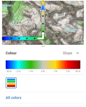
- Color schemes for terrain, tracks, and routes:
- Custom Color palettes.
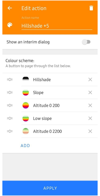
- Quick action button for terrain color scheme.
- The map legend for color palette schemes of tracks, routes, and terrain.
- Profile appearance redesign.
- 3D icons for My location.
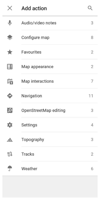
- The new Add action screen of the Quick Actions tool has been updated.
- Show / Hide actions for Routes on the map.
- Quick Actions on the external keyboard allow you to assign actions for personalized use.
- Weather UI has been updated with layer animations and improved label visibility.
- Improvements for the 3D track view.
- Detailed track guidance for Attach to the roads.
- Removed login/password authorization method in OpenStreetMap Editing plugin.
- More icons for Favorites.
- Added Water category of POIs.
- Updates for Compass button.
- Optional updates.
Altitude of Terrain Color Scheme
The feature displays the altitude of the terrain in different colors, which greatly improves the visual perception of the map. Easily recognizable different altitude levels with new color palette helps you better navigate the terrain and distinguish uplands from lowlands.
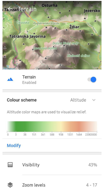
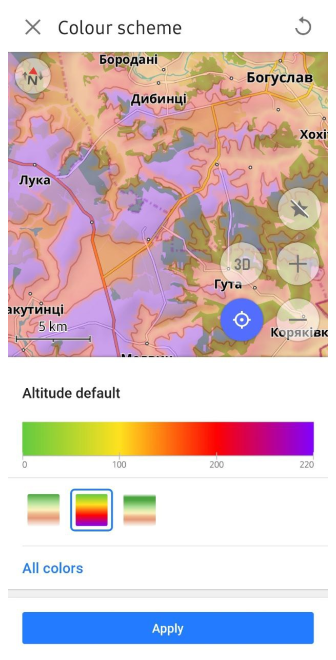
Color Schemes
New color palette schemes have been added.
- For routes: Speed, Slope, and Elevation (Altitude).
- For terrain: Hillshade, Slope, and Altitude.
- For weather: All weather layers.
Color palettes data is available in the Maps & Resources menu.
Menu → Maps & Resources → Local → Colors
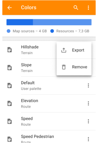
Custom Color Palettes
You can add your custom color palettes to OsmAnd. To do this, create a TXT file with the required name:
- Routes:
route_speed_name.txt,route_slope_default.txt,route_elevation_default.txt. - Terrain:
height_altitude_name.txt,hillshade_color_name.txt,slope_name.txt. - Weather:
weather_name.txt.
For example:
TXT file named *height_altitude_0-200.txt*

# 0 - 90 degree RGBA
0,46,185,0,191
# yellow
100,255,222,2,227
# red
200,255,1,1,255
# violet
220,130,1,255,255
After moving this TXT file to ..Android/data/net.osmand/files/color-palete/height_altitude_0-200.txt, a new palette will appear in the Color Scheme menu.
Quick Action to Switch Terrain Color Palettes
In this release, we have added the ability to switch between terrain color palettes, similar to switching between layers. This can be done using the Quick Actions tool.
Menu → Configure screen → Custom buttons → + → Add button → Add action → Topography → Change Terrain color scheme
Map Legend for Color Palette Schemes
The legend provides an easy way to view and understand the different markings on the map. New color palette schemes have been added to display speed for tracks, line type for routes, altitude and slope for terrain, and all weather layer color palettes.
 |  |  |
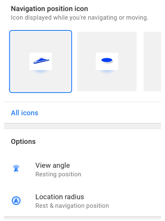
Profile Appearance Redesign
The appearance of profiles has been improved to make them more interesting, recognizable, and usable.
The update includes:
- New icon and color selection components.
- Redesign of the location icon selection map.
- Default 3D icons for map rendering Version 2 (OpenGL).
- Added Options menu for 3D icons:
- View angle. Status: Off, Resting position, Navigation position, Rest & navigation position.
Displays of the cone-shaped area you are currently in. - Location radius. Status: Off, Resting position, Navigation position, Rest & navigation position.
Displays a circular area that reflects the accuracy of your current location.
- View angle. Status: Off, Resting position, Navigation position, Rest & navigation position.
3D My Location Icons
A new 3D view has been added for My Location icons, which improves their visualization on the map. These changes bring the appearance of the icons in alignment with the 3D tilt of the map.
3D icons are only available for map rendering Version 2 (OpenGL).

Quick Actions Tool Update
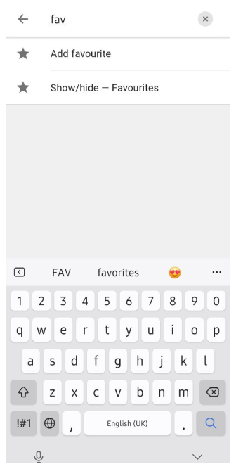
The updated Add Action screen makes it easier to customize and add Quick actions, improving access to important features. You can now find groups of actions, use the search function, and apply other actions to customize the Quick Actions tool, contributing to a better user experience.
Show or Hide Routes on the Map
Added a new quick action Show/Hide Routes on the map. Now you can turn on or off routes on the map with one tap.
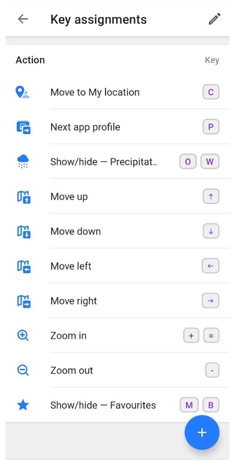
Quick Actions to External Keyboard
You can now assign all Quick Actions to external keyboard buttons. This is especially useful if you often work with the application using external input devices and need quick access to basic functions. The ability to customize quick actions in this way makes working with OsmAnd more flexible and efficient.
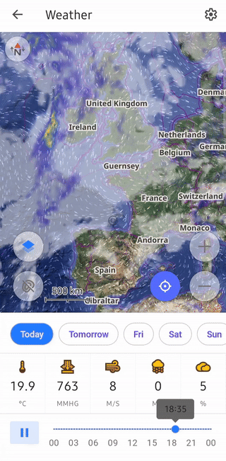
Weather Tool Improvements
Layer animations and improved labels make the weather interface more visual and informative. These changes help you better understand current weather conditions and forecasts. Improved label visibility makes navigating weather data much easier.
Improvements:
- New weather panel with an updated user interface.
-
Weather animation.
- After making sure the weather layers are selected, tap the Play button on the Weather screen.
-
A Wind animation layer has been added.
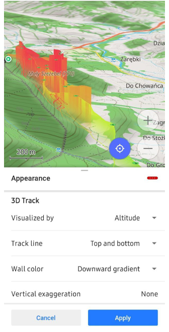
3D Track Improvements
Updated 3D track visualizations provide a more detailed view of routes. In this release, we have added the following improvements to the 3D track appearance.
-
Visualization options.
- If Visualized by is set to Fixed height,
→ change Vertical exaggeration to Wall height.
- If Visualized by is set to Fixed height,
-
Wall color options.
- You can choose from:
Solid, Downward gradient, Upward gradient, Altitude, Slope, or Speed.
- You can choose from:
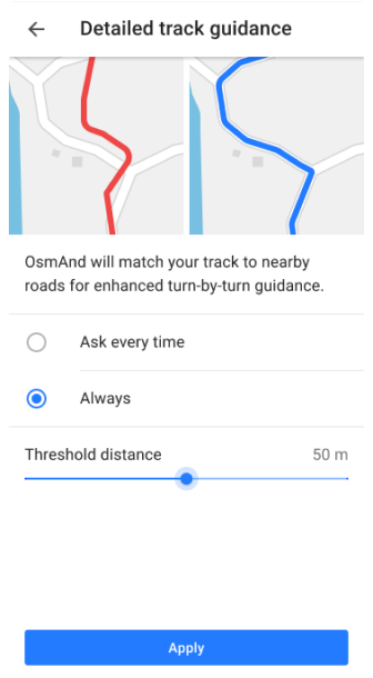
Update Attach to the roads
A new Detailed track guidance setting has been added for the Attach to the roads feature. The options for using the feature are:
- Ask every time. The button is always displayed when you create a route using Follow track in the Navigation menu.
- Always. Attach to the roads is applied automatically.
Navigation settings → Other → Detailed track guidance
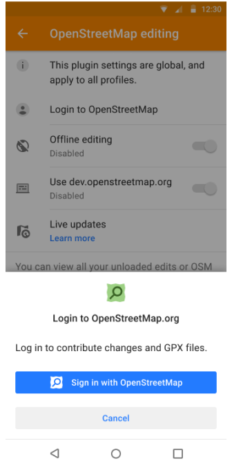
Login to OpenStreetMap
To improve security, the option to authorize with login and password has been removed. As of June 1, 2024, only the new secure OAuth 2.0 method will be supported. This authorization method provides a higher level of information security to help protect your data and prevent unauthorized access.
The Use username and password button has been removed from:
- Login to screen in the OSM Editing plugin menu.
- Benefits for active OSM contributors.
- Upload OSM Note dialog.
More Favorite Icons
A complete list of icons for Favorites has been added, which helps to organize and visualize them better. This allows you to search and select an icon for a favorite in a Сustom POI search from the icon library, making the use of favorites more convenient and efficient.
![]()
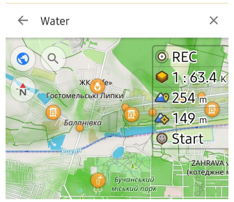
Water Category of POIs
The new POI Water (Man made) category includes objects with drinking water sources. Searching this сategories will help you easily find water on the map when traveling.
Compass Button Updates
The compass button has received updates that improve its functionality. These changes make the compass more accurate and easier to use, and help you navigate better.
- Single tap. Rotates the map orientation to the North in all orientations. Even if it rotates back in a second, such as in compass mode.
- Double tap. Switches map orientations. This previously worked with a single tap.
- Long tap. Opens a bottom sheet with a list of available orientations. This function remains unchanged.
Processed accessibility actions:
- Single tap. Rotates the map to the North in main mode.
→ This action corresponds to a Double tap in TalkBack. - Long tap. Opens the bottom sheet with orientations in main mode.
→ This action corresponds to a Double tap and hold in TalkBack. - Double tap to switch map orientation is not available in Accessibility mode.
Optional Updates
-
Significant speed improvement for Attach to roads algorithm.
-
Added Pale style for roads rendering.
-
Stair icon was added to the map at border nodes.
-
Added Energy and Rendering statistics to the Development plugin.
-
Added Brands for POIs categories.
-
Improved colors for multiple GPX tracks after import.
-
Updated detailed Sharing text screen for Android 14.
-
Using localized names for routes.
-
Fixed:
-
Bug with export-import of GPX files.
-
Incrorrect labeling of external temperature sensor data for GPX files.
-
An issue with navigation not stopping after reconnecting in Android Auto.
-
Sorting (statistics and search) of tracks folders in Configure map → Tracks.
-
Bug with 3D mode button tilt angle on the map.
-
Wrong elevation data on graph for tunnels, bridges in Route details.
-
Bug with copied "Custom button" from another profile.
-
Bug with malfunction when displaying Quick Action names.
-
Bug with not moving contact icon sharing of OsmAnd Telegram tracker.
-
Bug with icons sizes on Samsung DeX.
-
Follow OsmAnd on Facebook, TikTok, X (Twitter), Reddit, and Instagram!
Join us at our groups of Telegram (OsmAnd News channel), (EN), (IT), (FR), (DE), (UA), (ES), (BR-PT), (PL), (AR), (TR).

