Araç parametreleri
Genel Bakış
- Android
- iOS
Şuraya git: Menü → Profili yapılandır → Navigasyon ayarları

Şuraya git: Menü → Ayarlar → Uygulama profilleri → Navigasyon ayarları

OsmAnd'da optimum rota hesaplaması için aşağıdaki araç parametrelerini göz önünde bulundurmalısınız:
- Aracın minimum ve maksimum hızı olarak Varsayılan Hız veya Yol Hızları ayarını yapın. Bu, uygulamanın rotayı tamamlamak için gereken süreyi belirlemesine ve farklı yol segmentlerindeki hız sınırlarını göz önünde bulundurarak en iyi rotayı seçmesine yardımcı olacaktır.
- Motor tarafından kullanılan yakıtın tipini belirtin. Bu, uygulamanın CO2 emisyonlarını tahmin etmesini sağlayacaktır.
- Deponuzun kapasitesini girin; bu, yakıt seviyenizi ve tüketiminizi doğru bir şekilde takip etmenizi sağlar.
- Aracınızın boyut ve ağırlık parametrelerini tanımlayın; bu, uygulamanın optimum rotayı hesaplamasına ve kısıtlamalar nedeniyle yoldaki engellerden kaçınmasına yardımcı olabilir.
OsmAnd uygulamasındaki parametreleri doğru bir şekilde ayarlamak, bir rotada gezinirken sorunlardan kaçınmanıza, araç tipine ve yol kısıtlamalarına göre en uygun olanı seçmenize ve seyahatiniz için süreyi hesaplamanıza yardımcı olacaktır.
Boyut Parametreleri
- Android
- iOS
Şuraya git: Menü → Profili yapılandır → Navigasyon ayarları

Şuraya git: Menü → Ayarlar → Uygulama profilleri → Navigasyon ayarları

Araç parametreleri, yolların, köprülerin, feribotların, barajların ve diğer altyapının kullanılabilirliğini belirledikleri için navigasyonu ve rota oluşturmayı etkiler. Bir aracın yüksekliği, genişliği, uzunluğu veya ağırlığı belirli yol kesimleri için izin verilen değerleri aşarsa, OsmAnd navigasyon sistemi yol boyunca engellerden kaçınmak için alternatif bir rota bulacaktır.
- Ölçü birimleri, Genel ayarlar → Birimler ve formatlar bölümünde seçilen ayarlara karşılık gelecektir.
- Araç parametreleri manuel olarak ayarlanabilir.
- Araç ölçüm parametresini manuel olarak seçerseniz, uygulama size hazır listeden en yakın değeri sunacaktır. Bu, hatalardan kaçınmak ve rotayı daha doğru bir şekilde oluşturmak için gereklidir.
- Hazır bir boyut listesinden araç parametrelerini seçebilirsiniz.
- Boyutu ayarlamayın, Yok, yani seçilen parametreye herhangi bir kısıtlama uygulanmayacaktır.
Sınırlar
1. Ağırlık sınırı - Aracınızın ağırlığını belirtin, ağır araçlar için bazı rota kısıtlamaları geçerli olabilir. Ağırlık parametresi yalnızca Araba, Kamyon ve Motosiklet gibi navigasyon türlerinde mevcuttur.

2. Yükseklik sınırı - Aracınızın yüksekliğini belirtin, yüksek araçlar için bazı rota kısıtlamaları geçerli olabilir. Yükseklik parametresi yalnızca Araba, Kamyon, Motosiklet ve Tekne gibi navigasyon türlerinde mevcuttur.


3. Uzunluk sınırı - Aracınızın uzunluğunu belirtin, uzun araçlar için bazı rota kısıtlamaları geçerli olabilir. Uzunluk parametresi yalnızca Araba, Kamyon ve Motosiklet gibi navigasyon türlerinde mevcuttur.

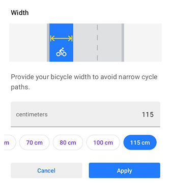
4. Genişlik sınırı - Aracınızın genişliğini belirtin, geniş araçlar için bazı rota kısıtlamaları geçerli olabilir. Genişlik parametresi yalnızca Araba, Kamyon, Motosiklet ve Tekne gibi navigasyon türlerinde mevcuttur.


Android'de, bu parametre dar bisiklet yollarından kaçınmaya yardımcı olmak için Bisiklet profilleri için de mevcuttur.
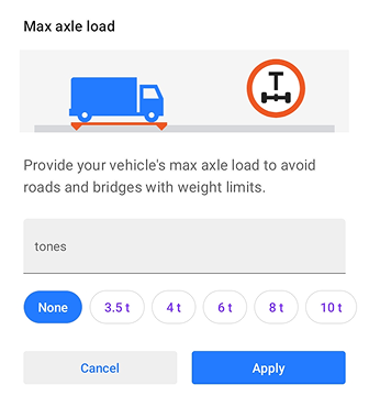
5. Maksimum aks yükü sınırı - Araç aks ağırlığı kısıtlamalarına sahip yollar ve köprülerden kaçınmak için aracınızın maksimum aks yükünü belirtin. Bu parametre yalnızca Kamyon gibi navigasyon türlerinde mevcuttur.
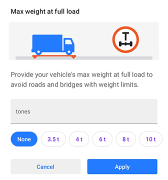
6. Tam yüklü maksimum ağırlık - Genel ağırlık kısıtlamalarına sahip yollar ve köprülerden kaçınmak için tam yüklü aracınızın maksimum toplam ağırlığını belirtin. Bu parametre yalnızca Kamyon gibi navigasyon türlerinde mevcuttur.
Araç parametrelerindeki sınırlar, navigasyon ve yol güvenliği için önemli olabilir. Bu kısıtlamalardan bazıları şunları içerebilir:
- Belirli kentsel alanlarda hareket eden araçlara yönelik kısıtlamalar.
- Köprüler, sınırlı alana sahip tüneller, alçak üst geçitler, karmaşık dönüşler veya diğer yapılar gibi belirli yol kesimlerinde araç hareketine yönelik kısıtlamalar.
- Araç aksı başına ağırlık limitleri, kamyonlar için özellikle önemli olabilir.
- Yüksek sıcaklıklar, ıslak veya karlı yollar, gece veya sınırlı görüş mesafesine sahip hava koşulları gibi belirli koşullarda hareket eden araçlara yönelik kısıtlamalar.
Yakıt parametreleri
Motor Tarafından Kullanılan Yakıt
- Android
- iOS


Araç parametrelerinde motor tipini seçerseniz, Rota Detayları bölümündeki grafiğin üzerinde CO2 ayak izi verileri görüntülenecektir. Mevcut altı yakıt tipi: Benzin, Dizel, LPG, CNG, Elektrik, ve Hibrit.
Uygulanabilirlik:
Motor tarafından kullanılan yakıt ayarı yalnızca Araba, Motosiklet ve Kamyon gibi araç tabanlı navigasyonlarda mevcuttur.
Yakıt deposu kapasitesi
- Android
- iOS


Yakıt deposu kapasitesi parametresi, deponuzun toplam hacmini sağlayarak aracınızın yakıt seviyesini ve tüketimini daha doğru bir şekilde takip etmenizi sağlar. Varsayılan değer ~50 litre'dir. Yakıt kapasitesi için ölçü birimi, Menü → Profili yapılandır → Genel ayarlar → Birimler ve Formatlar → Hacim birimi bölümünde yapılandırılan Profil (Ayarlar) tarafından belirlenir.
Uygulanabilirlik:
Yakıt deposu kapasitesi ayarı yalnızca araç tabanlı navigasyonlarda mevcuttur. Bisiklet, At binme, Yaya ve Kayak gibi navigasyon türleri için bu parametre Araç Parametrelerinde görüntülenmez.
Hız parametreleri
Varsayılan Hız
- Android
- iOS


Varsayılan hız, bu ulaşım modu için varsayılan hareket hızıdır (Varsayılan hız limitleri). Yürüme, At binme ve Bisiklet profilleri için 0,1 km/saat (mph) (Birimler ve formatlar) eşdeğeri küçük artışlarla, diğer profiller için ise 1 km/saat (1 mph) eşdeğeri artışlarla. Kullanılır:
- GPX Navigasyonu, Kayak rotaları, Tekne rotaları, Yaya ve diğer benzer profiller gibi yollardan hız belirlenemediğinde rota süresini tahmin etmek için.
- Sesli anonsların ne zaman etkinleştirileceğini belirlemek için.
- Ortalama hız henüz hesaplanmadıysa, düz çizgi navigasyonu ile Harita işaretleyicileri için tahmini varış zamanını belirlemek için.
Varış zamanını hesaplamak ve uygulamanın tipik olarak kabul ettiği hareket hızına göre (örneğin, araba, toplu taşıma, yaya veya manuel olarak ayarladığınız hız) en uygun rotayı belirlemek için kullanılır.
Yol Hızları

Bazı navigasyon türleri için minimum ve maksimum izin verilen hız ayarlanabilir. Ayarlanırsa, rota motoru aracın veya ulaşım modunun limitten daha hızlı hareket etmeyeceğini ve minimum hızdan daha yavaş hareket etmeyeceğini varsayar. Örneğin, yakıt tüketiminin ayarlanan maksimum hızda optimal olduğu ve motorun daha uzun ama daha hızlı yollardan kaçınarak daha kısa bir rota bulacağı yakıt verimli bir rota oluşturmaya olanak tanır.
- Minimum hız
Ayar, rotadaki tüm yol türleri için minimum sürüş hızını belirler. Önerilen hızı minimum hızdan daha düşük olan yollar için önceliği artırır. - Maksimum hız
Ayar, maksimum sürüş hızını belirler ve olası hızı maksimumdan daha yüksek olan yollar için önceliği azaltır.